
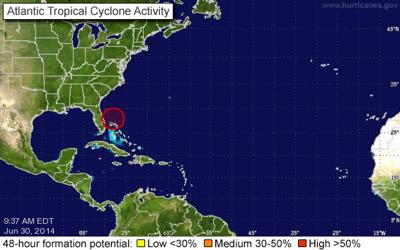
The National Hurricane Center forecasters give an area of disturbed weather off Florida’s Atlantic coast an 80% chance for development into a depression or named storm (Arthur) within five days.
Hurricane Hunters are in stand by mode waiting on the word later today to fly out and measure the disturbance. Models are in very good agreement with the southwest movement of the system over the next 24 hours.
As the system moves closer to the state the risk of flooding rains goes up. The risk is most pronounced for the central and south central east coast of Florida. From the Space Coast to Miami there is the potential for 2 to 4 inch rainfalls if a condition called training sets up. Training occurs when storm after storm follows the same line over the same location. The heaviest of rains will likely remain off the Atlantic coast. Some urban flooding is possible with rains of this nature should they materialize.
There is more uncertainty than usual with a summertime forecast due to questions about the eventual strength and also movement of the system.

(0) comments
Welcome to the discussion.
Log In
Keep it Clean. Please avoid obscene, vulgar, lewd, racist or sexually-oriented language.
PLEASE TURN OFF YOUR CAPS LOCK.
Don't Threaten. Threats of harming another person will not be tolerated.
Be Truthful. Don't knowingly lie about anyone or anything.
Be Nice. No racism, sexism or any sort of -ism that is degrading to another person.
Be Proactive. Use the 'Report' link on each comment to let us know of abusive posts.
Share with Us. We'd love to hear eyewitness accounts, the history behind an article.